

Powering Discoveries
Faith Singer
Bracing for the Big Ones
Earthquake, tsunami, climate flooding data win 2023 DesignSafe Dataset awards

No one knows for certain when a natural disaster will strike. But a small handful of extreme events — severe earthquakes and storm floods — can be expected to occur near the West Coast of the U.S. every 50-100 years, according to a statistical analysis of historical records.
Two datasets — one on seismic and tsunami hazards of a coastal Oregon town and another on California “plausible worst-case scenario” flooding — have received a 2023 DesignSafe Dataset award given in recognition of the diverse contributions of each dataset to natural hazards research.
DesignSafe is a comprehensive cyberinfrastructure that is part of the NSF-funded Natural Hazard Engineering Research Infrastructure. It provides cloud-based tools to manage, analyze, understand, and publish critical data for research to understand the impacts of natural hazards. The cyberinfrastructure and software development teams are located at TACC.
Seaside Attraction
 The resort town of Seaside, Oregon (pop. 7,115) is the focus of a study that modeled community response in the crosshairs of potential disaster. Seaside’s low-lying topography and proximity to the Cascadia Subduction Zone makes it vulnerable to earthquakes and tsunamis.
“Its small community size allowed us to look at granular, parcel-level information,” said Dan Cox, a professor in civil engineering at Oregon State University. “Each building was accounted for in our study rather than a bird’s eye view of a larger area.”
The data detail peak ground acceleration and deformations, as well as maximum tsunami water inundation, velocity, and momentum in intervals ranging from 100 to 10,000 years.
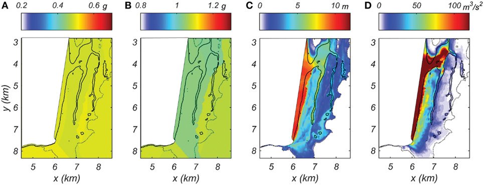
Importantly, the dataset combines built, natural, and human systems that can be used for modeling community resilience.
“Resiliency depends on resources and the rapidity with which the community can bounce back,” said dataset co-author Andre Barbosa, a professor in structural engineering at Oregon State University. “Resilience tells you how robust your infrastructure and social systems are, and how fast they can recover after a big extreme event.”
This study evaluated different policy options and actions. For example, after a building gets sold, the owner is now required to retrofit it. Another policy includes the number of Vacation Rentals by Owner that are allowed in a community, and what the unintended consequences are if a large disaster were to happen.
“It’s a very unique study because it integrates an urban change model with research that looks at the risk and impact of natural disasters on communities,” Barbosa said.
The team said DesignSafe’s publishing tools and the direct object identifier created for the dataset were instrumental in sharing the data effectively.
“Mitigation matters,” added Barbosa. “In community resilience studies with these types of datasets, communities and other researchers can use different policies and mitigation strategies to become more resilient.”
The data in the Seaside Testbed (PRJ-3390) has been used in over a dozen scientific studies, including research published in December 2022 in the journal Earth’s Future by the American Geophysical Society.
Coming ARkStorms
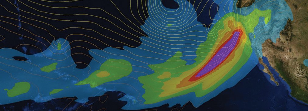 In 2010, the U.S. Geological Survey conducted a “what-if” scenario of an extremely powerful rainstorm that struck California, which they called ARkStorm 1.0 — short for Atmospheric River (1k).
ARkStorm 1.0 found that widespread flooding and wind damage along the Central Valley of California from a 25-day deluge of atmospheric rivers would cause billions of dollars of damage to property and infrastructure and widespread evacuations of millions of people.
But it didn’t account for climate change, which scientists predict increases atmospheric water vapor and could increase the intensity of mega storms.
Enter ARkStorm 2.0 — an updated scenario that takes climate change into account by embedding a high-resolution weather model inside a climate model using the climate conditions as the boundary conditions.
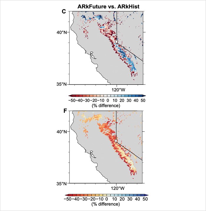
Scientists embarked on the first of three phases of ARkStorm 2.0 in 2022: the development of the atmospheric scenario. They completed a dataset that includes the initial condition, forcing, and configuration files for the Weather Research and Forecasting Model (WRF) simulations used to develop the hypothetical extreme storms.
It also includes WRF output meteorological data such as precipitation, wind speed, snow water equivalent, and surface runoff to characterize natural hazard impacts of the storm simulations.
“The ARkStorm 2.0 dataset is curated from an impacts-based perspective,” said Daniel Swain of the University of California, Los Angeles. “We tried to include the variables most important for doing follow-on analyses to understand the impacts to people, infrastructure, and ecosystems in these scenarios.”
“This dataset has been shared with the U.S. Federal Emergency Management Agency; the California Department of Water Resources; the Governor’s Office of Emergency Services; and other entities because there is real interest in gaming this scenario out from an infrastructure and risk assessment perspective,” Swain added.
The datasets produced by the ARkStorm 2.0 scenario are voluminous, making DesignSafe the perfect choice to host and share the data.
“DesignSafe — it’s in the name,’ Swain said. “This is very much infrastructure, design, and risk assessment-relevant. The repository is well-designed to accommodate sharing with various state and federal agencies.’
The dataset, PRJ-3499 | ARkStorm 2.0: Atmospheric Simulations Depicting Extreme Storm Scenarios Capable of Producing a California Megaflood, is publicly available on the NHERI DesignSafe cyberinfrastructure website.